These rules govern traveling through hazardous mountains where there are no actual roads. They are used alongside the WFRP 4e rules for camping, hunting and foraging utilizing the Outdoor Survival skill and an actual Random Encounter table which is not reproduced here.
Procedure
- Each day choose route or direction
- Make a Navigation Test for the distance traveled with the units die used for the Encounter Roll
Movement Rate
- Base movement rate = 1mile/hour
- Can travel for 8 hours/day with 30 min break every 2 hours, so 10 hours total
- Can push on for weakest party member's Toughness Bonus in hours
- All make Average Toughness test (adjusted by weather and encumbrance) or Fatigued till sleep
Navigation Test
There are 2 grades of route delineated on the map; solid and broken (pink lines in header image).
Solid is considered to be terrain which can be walked or potentially ridden on, though slowly. Mostly these are along the bottom of the great valleys.
Broken may be up mountain stream beds or broken ground which involves scrambling and occasionally some climbing. Generally mules can be lead over broken routes.
Set the Navigation test difficulty as follows:
- Solid route = Average (+20)
- Broken route = Challenging
- No route = Hard (-20)
- Increase Difficulty by one step for Bad weather
- Increase Difficulty by one step if no Knowledge of route
Success
A Critical counts as an additional 2 SL (Success Levels).
- 1 per extra mile traveled
- +1 SL Outdoor Survival test to find/set camp
- +1 SL Outdoor Survival test to forage/hunt
- +1 to Encounter Roll
- +1 SL to Track tests
- Gain Knowledge for next day's travel
Failure
If Fumble the party will be Lost in addition to all other penalties.
Suffer all that apply:
- FL 1- 3: -1/FL to miles traveled
- If No route an Average Extended Climb test with Target = FL is required by the poorest climber
- A fumble means fall - lose something or take 1d10 wounds
- For every roll required -1 to miles traveled
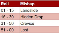
- FL 4: Roll Mishap
- FL 5: -1 to Encounter Roll
- FL 6: -1 SL Outdoor Survival to find/set camp
Encounter Roll
- Use units die from the Navigation test
- If an encounter takes place a second d10 is rolled to determine distance, the skill test dictates who sees who first
- SL & FL from the Navigation Test can push the encounter roll up or down
- The actual encounter content is rolled on another table
- If it is important when an encounter takes place roll % of days travel
- if critical it will be at best time, fumble at worst
Mishaps
Landslide
- sudden rockfall causes 1d10 damage to everything in its path
- make Challenging Dodge test to avoid
- Fumble = Fall, take additional 1d10 wounds or lose something
- Critical = Save a colleague from damage
Hidden Drop
- Lead character make Hard Perception (-20) test to spot
- make Challenging Athletics test or Fall, taking 1d10 wounds or lose something
- 2nd Character must make Average Initiative test or do same
- Lose 1 mile traveled in attempt to circumvent
Crevice
- Units die * 10 = % through day's travel its encountered - round up to nearest mile
- Either go back and lose the time or try to cross
- To cross its a Challenging Climb or Fall taking 2d10 wounds
- Its Units die * 5 yards across (in case party want to create crossing)
- If they all climb it costs 1 mile traveled
- If the construct a crossing it costs 2 miles traveled
Lost
- If Character Navigating has the Orientation talent the Mishap will be Crevice instead
- Otherwise roll 1d6 with 1 being North, 2 NE etc - this is the actual direction traveled today
Commentary
These rules were devised for exploring the Middle Mountains as part of The Horned Rat. I'm not keen on the general scene based approach of WFRP where one thing happens after another with limited choice for the players. I've striven to do something more sandboxy and OSR like. I even imposed a 6 mile hex grid on the official map.
It seems to work well enough, although no mishaps have occurred yet. Giving the players the choice of what to spend Success Levels on makes each roll more interesting and full of consequence. Having the Encounter roll be on the units die helps keep the number of rolls down.
In addition to the hex grid I drew the solid and broken routes on the mountains and gave them names, the Sturmtaal, the great SW-NE glen on the western side of Karak Skygg, the Taubertaal on the eastern side. Knowledge of the mountain tracks could be gleaned from villages on the outskirts or hunters on the slopes. Or from judicious use of a Lie of the Land spell.
I've left out the Random Encounter tables as we're still actually playing The Horned Rat...


No comments:
Post a Comment